By Dan England
Spring is coming, and you’re probably ready to rub your eyes and emerge from hibernation for a few hikes. Unfortunately, the mountains are still slathered in snow.
Those 14ers, our most popular peaks to hike, probably won’t be clear of snow until mid-June at the earliest, and some take until the 4th of July to clear. Many peaks in Rocky Mountain National Park, or most of its trails, for that matter, will likely be in the same condition.
So, what can you do in the meantime? Well, there’s plenty of local hikes in Northern Colorado that should be clear of snow, at least by April, barring any crazy spring snowstorms (and you should count on at least one, so always check for trail conditions). These are fun hikes to do all year, of course, but we think they are terrific in the spring, while you wait for the snow to melt up higher and summer’s heat won’t melt you in the meantime.
Conditions vary this time of year, of course, as they will for all spring hikes, so we’ve included information on how to find the latest trail conditions. But that’s a tricky thing, so we recommend wearing shoes or boots sturdy enough to handle snow, ice, thick mud, wet rocks or dry, dusty trails. Also, we’ve tried to include some out-of-the-way trails here, but many of these are popular hikes, so the best way to beat the crowds (and any kind of weather, whether that’s stormy skies, the wind or heat) is to get there early, from sunrise to an hour later.
The Keyhole on Devil’s Backbone
Devil’s Backbone, on the western edge of Loveland, may be the most impressive rock formation in all of Colorado. It really does look like a backbone. Why do they say it belongs to the Devil? Try hiking this uncovered path, awash in sunshine, in August. Therefore, now’s a good time to experience this busy but beautiful hike when it’s not as hot. This hike is nearly 2.5 miles round-trip, and you gain a manageable 250 feet in elevation.
Free parking. For information on conditions: larimer.org/naturalresources/parks.
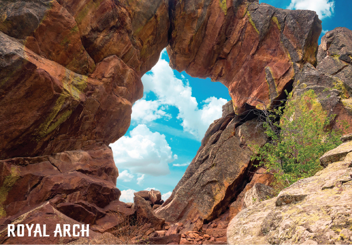
Royal Arch
This may be the most popular trail in Boulder’s fantastic Chautaqua Park, but that’s because the arch is one of the wonders of Colorado, along with the fantastic Flatirons, and this hike gives you amazing views of both. It’s also good training for 14ers, as the flat beginning fools hikers into relaxing before the 1,200 feet of elevation gain comes charging to greet them. You’ll hike nearly four miles to the arch and back.
Some paid parking exists in the main lot, but unless you leave early, you won’t find a spot. Parking is available on the roads leading up to the trailhead, but that’s limited as well. Shuttles ran during the summer last year. For information on conditions:
bouldercolorado.gov/osmp.
Joe Wright Reservoir
Cameron Pass is one of the best places in Northern Colorado to snowshoe, as it tends to keep snow longer than many other area trails, and the snow tends to be fresher than standbys such as Rocky Mountain National Park. This is a nice, short loop hike less than two miles from the trailhead and back. You’ll gain a measly 125 feet. The hike even starts with a descent, as you follow the signage down to the start and the popular reservoir. “Of course, winter recreation is generally very popular in the Cameron Pass area as well,” says Reghan Cloudman, spokeswoman for the U.S. Forest Service. Other good snowshoes in the area include Zimmerman Lake and Blue Lake.
Free parking. For more information on conditions: fs.usda.gov/arp.
Horsetooth Falls from Soderberg
This is a beautiful, easy-going hike, great for kids and perfect in the spring, when the water is flowing the hardest (pay attention to when the rivers are high, which is an indication of snowmelt, which powers these falls as well). This way avoids the crowded Horsetooth Mountain lot and trails, though you’ll eventually run into them, and adds some heft to a hike that’s honestly a little too easy otherwise. Take Tower Road and then take a left when the Stout trail crosses it. You’ll go more than three miles and gain more elevation than the other route, but that’s what you wanted, isn’t it?
Parking $9. For more information on conditions: larimer.org/naturalresources/trails.
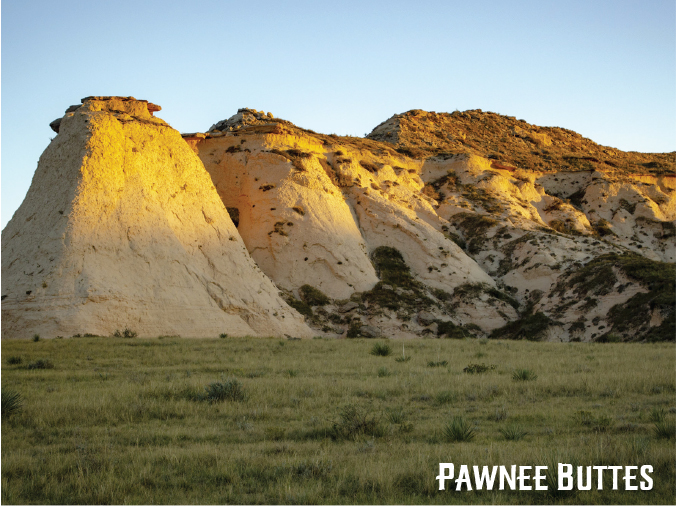
Pawnee Buttes
Located in the northeast corner of Weld County, you’ll think you’ve been swept away to Kansas, as the Grassland presents the best of the prairie, not the mountains. But you’re not in Kansas, as these Buttes look more majestic than a field of wheat. A trail a mile-and-a-half long leads hikers to the first Butte. The second is on private land, so if you see a gate, leave it alone. There is a closure nearby for raptor nesting, but the Butte trail is open year-round. This is also a wonderful place to stargaze.
Free parking. For more information on conditions: fs.usda.gov/recarea/arp.
Mount Sanitas
Mount Sanitas is more of a workout than a hike, and many treat it as their own Incline, the famous stair-steppin’ steep saunter up Pikes Peak. This is not as steep, but it is steep enough to train you well for the 14ers or any other mountain you may wish to climb, with a beautiful view on top. If you take the tough trail, you’ll go a bit more than three miles and gain more than 1,300 feet.
Free parking. For more information on conditions: bouldercolorado.gov/osmp/mount-sanitas-trailhead.
Greyrock
Now we are getting to the serious warm-ups before you climb any 14ers this summer, or this is a chance to push yourself to climb a mountain, even if you never intend to do another one. Greyrock is a unique formation that feels a lot higher than its 7,500 foot elevation up the Poudre Canyon. You do gain 2,500 feet if you take the Greyrock Meadows Loop Trail (and you should), and you’ll travel just more than seven miles. The summit is special, and not just for the views: A small lake rests between two points. Free parking. For more information on conditions: fs.usda.gov/recarea/arp.
Poudre Trail from 71st Avenue in Greeley, the “red barn” trailhead
If you don’t mind hiking on concrete, you’ll see one of the prettiest parts of Greeley, as this is my favorite section of the trail in Greeley. If you drive to this trailhead, you’ll want to head north out of Greeley on 71st Avenue. You’ll pass Northridge High School on your right and go down a steep hill. Follow the road left and you’ll see a parking area. You can go either east or west and see a beautiful section for more than a mile either way, and there’s a third section in the so-called Signature Bluffs Natural Area to the west of the 71st Avenue portion that features a soft trail that winds through a brief patch of woods that feels more like an exploration than a detour. Free parking. For more information on conditions: fs.usda.gov/recarea/arp.
Emerald Lake
This is a terrific beginner’s snowshoe in one of the most popular areas of Rocky Mountain National Park. So yes, it’s a crowded hike, but it’s not as crowded in the winter, especially if you go on a weekday or get to Bear Lake before 8 a.m. I call this the perfect beginner’s snowshoe because you actually get three nice-looking lakes in one hike, the paved section in the beginning gives you a chance to walk a bit instead of snowshoe, and you can stop before you reach Emerald and still feel like you had a good day. The hike is three-and-a-half miles round-trip, a significant snowshoe by many standards, with an elevation gain of 650 feet. RMNP is a crapshoot, as a snowy day usually means gorgeous snowshoeing terrain, and a dry one usually means an icy trail packed down by the crowds. Other great snowshoes in the park include Mills Lake and Bierstadt Lake. A one-day pass is $25 and a seven-day pass is $35. For more information on conditions: nps.gov/romo.
Coyote Ridge Natural Area
This is my new favorite place to train for ultramarathons, as the trail goes a long way past some beautiful spots and connects to both Rimrock Open Space and the Blue Sky Trail, which eventually leads you to Devil’s Backbone without trudging over the tiresome rock that covers the trail in the beginning. But you can take this trail as far as you want and still get a good workout and see some beautiful sights. I have run 28 miles on it, but you can go less than a mile before the real climbing begins and starts getting fun.
Free parking. For more information on conditions: fcgov.com/naturalareas.
Arthur’s Rock
This is a similar hike to Horsetooth Rock without the huge crowds. This hike still offers you the same view, challenges and adventure of Horsetooth. Take this trail up, up and up until you reach the top. The trail is 3.4 miles round-trip, with an elevation gain of 1,100 feet. I believe this hike is prettier, too, and cooler, as most of the trail winds through trees. There’s even a fun tiny scramble at the end just like Horsetooth. A daily pass to Lory State Park, which has many other trails in addition to Arthur’s Rock, is $8. For more information on conditions: cpw.state.co.us/arthurs-rock.
Rabbit Mountain
This doesn’t feature the rabbit ears of Steamboat Springs, but this lesser-known hike in Longmont is one of the mellowest ways to climb a mountain. You’ll see plenty of wildflowers in the spring and summer and nice colors in the fall. It’s only 5,800 feet higher, too, so snow shouldn’t be much of an issue in normal conditions past March. The hike ends at an overlook with two benches for a quick rest before you head back. You’ll cover six miles when you’re back at the car and be ready for any 14er that comes your way.
Free parking. For more information visit hikingproject.com/trail/7002305/rabbit-mountain.